Trip Report: La presqu'île de Crozon
The weather of Bretagne is well-known in France for its cantankerous behaviour. A rugged coastal region representing the far west of the metropolitan area, the conditions reminded me of Wellington on an average day… so I felt right at home.
“En Bretagne, il ne pleut que sur les Parisiens”
In Brittany, it only rains on Parisians
In Europe, August means summer holidays—at this time of year, most shops and many bars in Paris (outside of the tourist areas) have a taped hand-written or Calibri-font sign saying “en vacances estivales”, with most closing for a few days, if not a few weeks. With a strategically-timed public holiday, and a couple of keen/misguided friends (Jill & Arthur), we were soon planning a four day tramp (hike) around the presqu’île de Crozon. Here’s how it went.
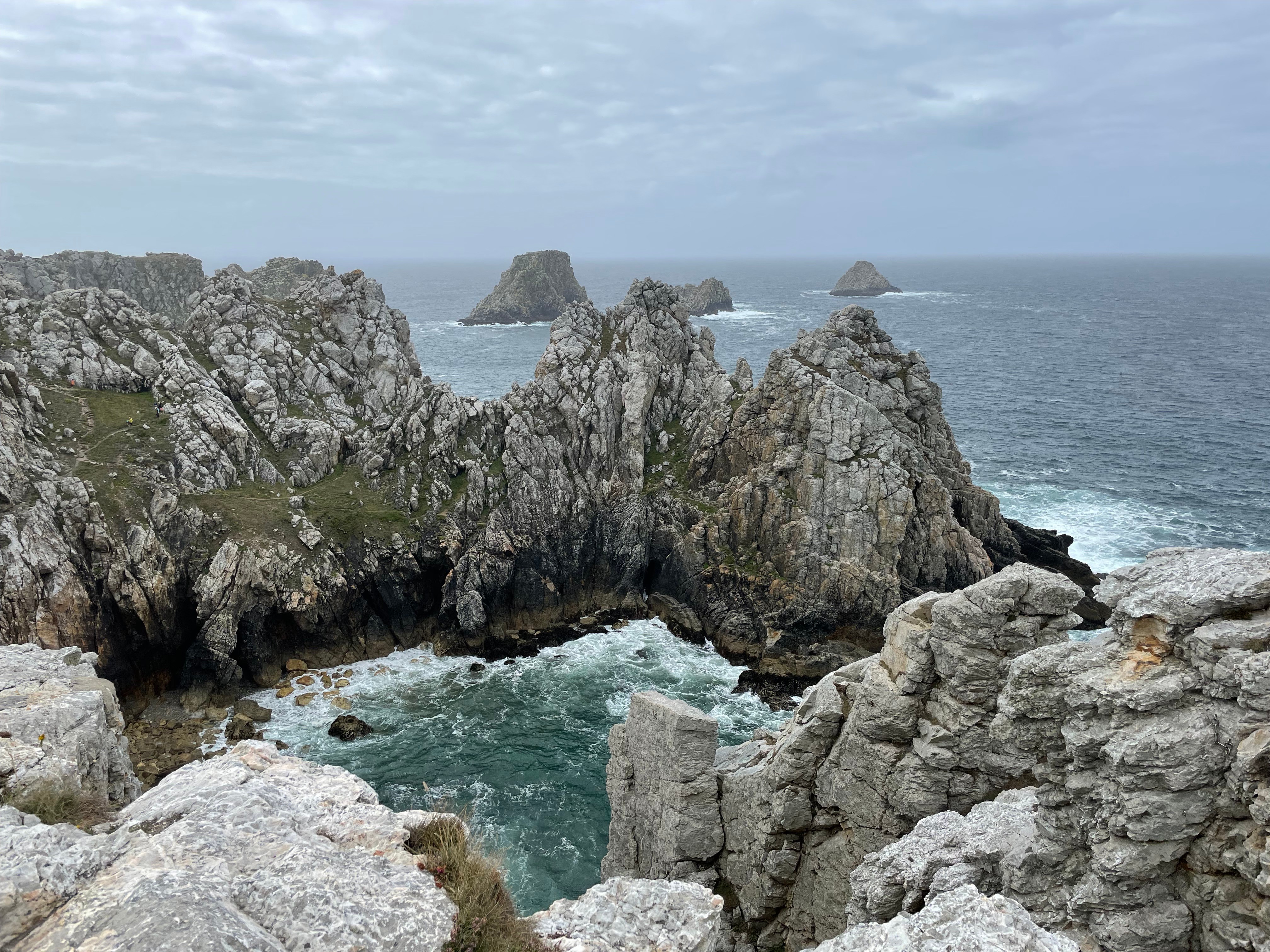 The ‘Pointe de Pen-Hir’, a dramatic site emblematic of the area
Day 0: Getting there
Following a long train journey (due to railway maintenance), a supermarket shop in Brest, a bus ride, then a region-provided ‘transport on demand’ taxi (part of the €2.50 bus fare), we arrived in Roscanvel. The grey and slightly drizzly weather did not dent our enthusiasm for a quick ice-cream pit stop, after which we headed to the inland municipal campsite. I had purchased a tent earlier in the week and was lucky to be setting it up for the first time in the presence of friends as a surprising amount of force was required to set up the poles.
Day 1: The fog
Despite waking up to a grey low clouds and humid fog, the weather was sufficiently mild as we joined the GR 34 trail ‘Le sentier des douaniers’, a 1700 km path winding its way around the coast of Bretagne. Weaving through country houses and fields by way of quiet roads and gravel paths, we ended up at the ‘Pointe des Espagnols’, the northern-most extremity of the peninsula. After a brief look at under-renovation military installations, we continued as the trail switched from bucolic fields to a rocky coastline interspersed with hulking concrete military installations. Many were boarded up, but the odd one had some sneaky street art.
Lunch was at a viewpoint from which we were meant to see the ’Îlot des Capucins’, however the fog meant that we could only make out a few dull shapes if we stared long enough. The low fog gave the sensation of being in a low-resolution game, with us only being able to see a certain number of metres in each direction—a peculiar sensation when looking down from a cliff and hearing the sea but seeing nothing but white clouds.
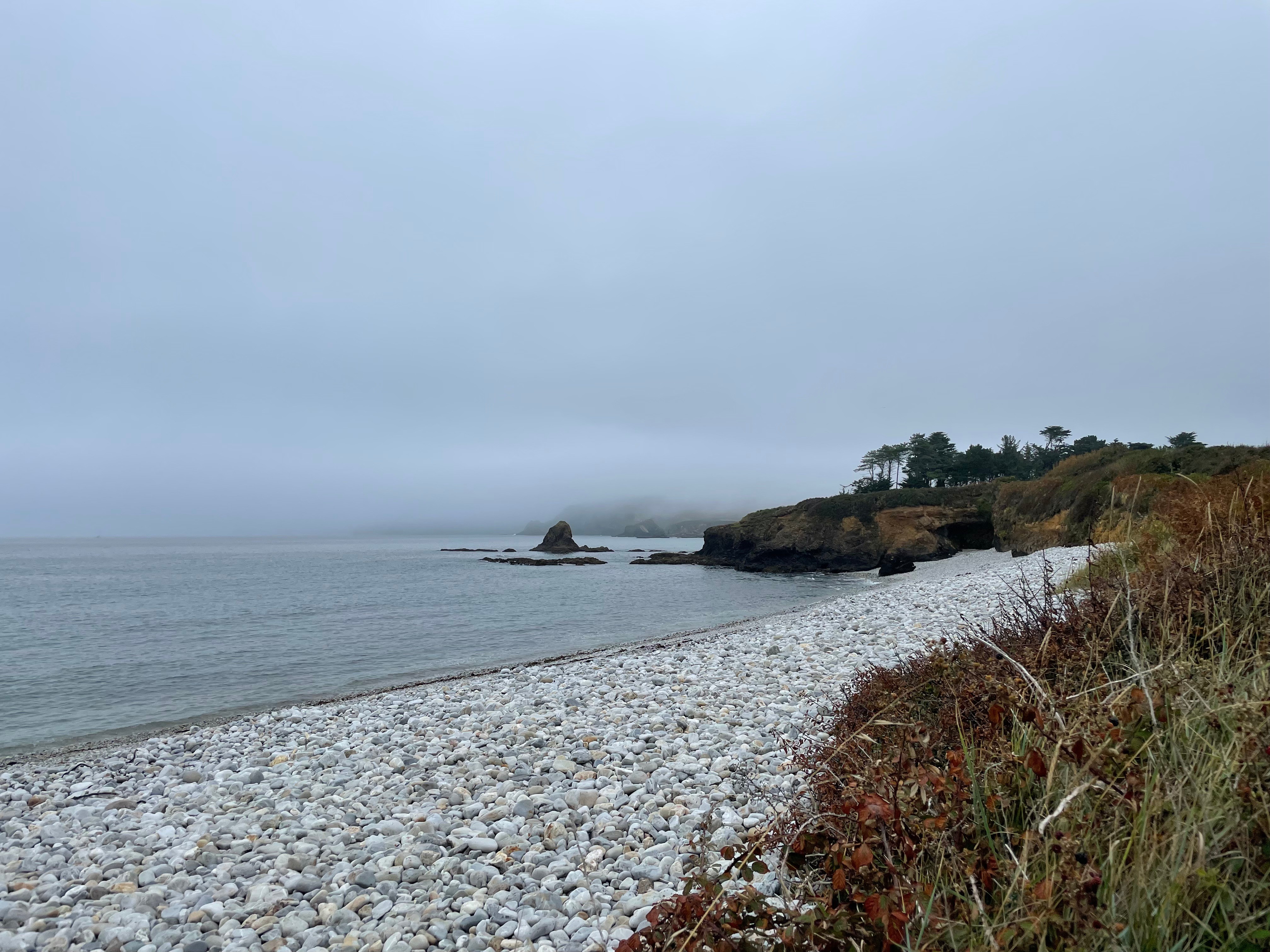 Waiting for the scenery to load
The trail continued along the coast through a multi-coloured quilt of ground-hugging shrubs, passing by a few beaches and behind an active military installation. We paused on one of these beaches to throw a few stones, and watch hardier souls go for a swim or explore the nearby rock pools. Eventually we arrived at the town of Camaret-sur-Mer, where we stocked up on a few supplies and paused for a juice at a waterfront bar, before heading to the campsite to pitch our tent.
Day 2: The wind
As we departed the campsite, we noticed many people wandering around with croissants and baguettes… of course being in France the campsite had a ‘Dépôt du pain’ from which you could buy bread and pastries. Unfortunately for us, they had run out of croissants! Taking a shortcut back to the trail, we were once again braving the wind-swept coast line. Passing by a rather impressive stone wall followed by a sandy beach, we wound our way along to the ‘Pointe de Pen-Hir’, complete with piles of day-trippers also out enduring the strong winds. After briefly stopping for a few photos of some rocky-looking rock formations, military hardware and a statue of a cross, we continued our way east to a much quieter part of the trail. We passed by some beautiful old rock walls, filled with flat colourful shrubs spilling out of the fissures between the stones and on to the patchwork surrounding them.
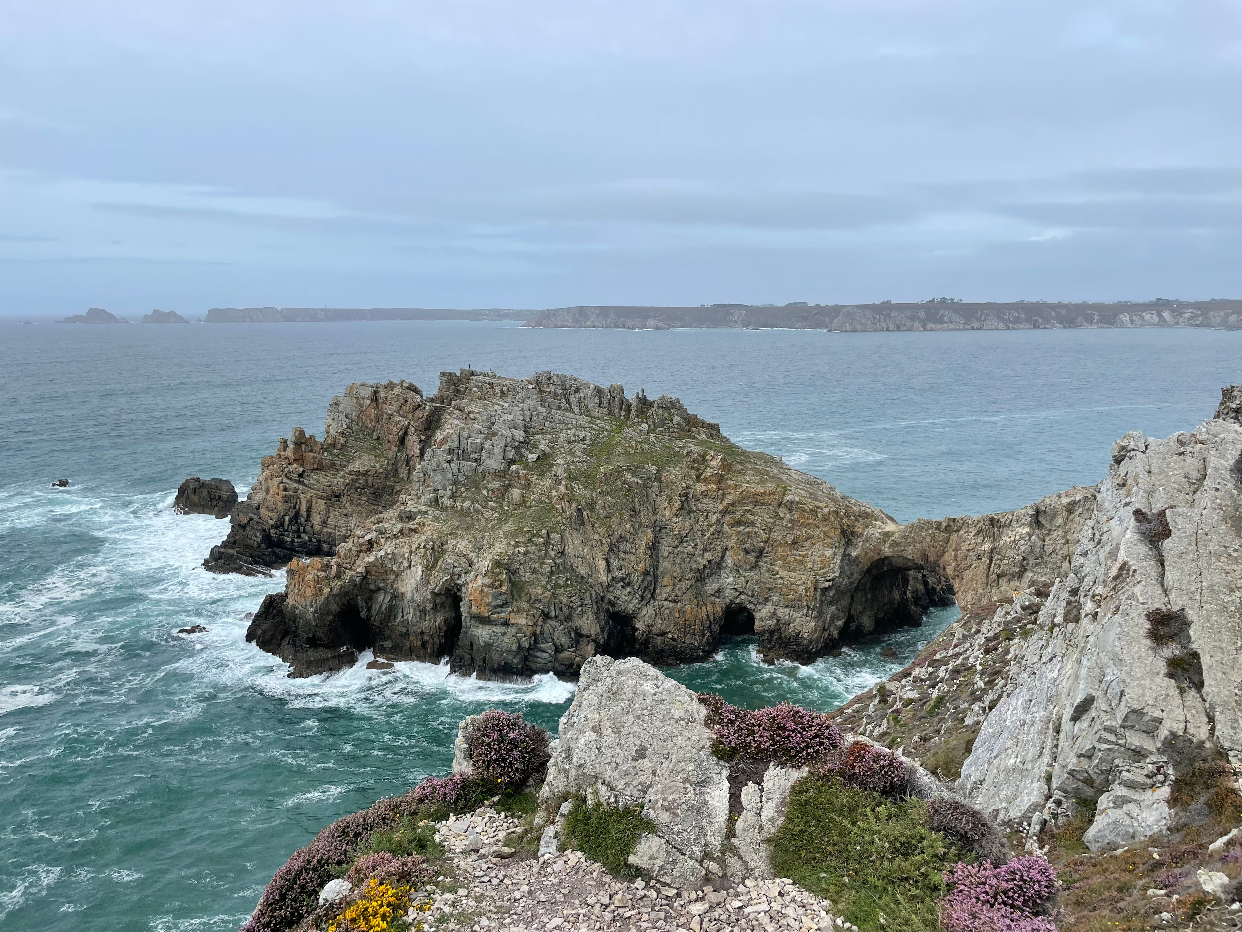 Who needs to build a castle, when nature can make one for you
Lunch was had on rather low picnic table next to a small beach, then we popped over a headland to a much larger beach. From here we climbed back on top of the cliffs, passing by a cool natural bridge to a jagged outcrop called the ‘Château de Dinan’. After a sharp descent followed by a reasonably rapid ascent, we turned inland to head to a campsite for the night. It was well-appointed, with a little bar/shop and the ability to order breakfast croissants—we took full advantage of this, enjoying a cheeky bevvy before dinner followed by an ice-cream afterwards.
Day 3: The sun
At this point I haven’t mentioned too much about the type of food we were eating outside of opportunistic croissants and ice-creams—that’s on purpose, because it wasn’t very glamorous. It was nonetheless sufficient to keep us going throughout the trip, and if you want to know more you’ll have to ask one of the people on the trip.
Day 3 started with blue skies, and it wasn’t long before we were (mostly) retracing our steps to rejoin the coast, descending eventually to a beautiful sandy beach. Continuing our journey south to the ‘Cap de la Chèvre’, we ended up back on top of the cliffs comme d’hab (as usual).
 Jill showing enthusiasm
Evidently the blue sky inspired others to get out and about, as the closer we got to the cape, the busier the trail got. At least one person bit off more than they could chew, with four medics heading out with a stretcher along the uneven rocky trail as we were having a snack. The wind was still making an appearance, particularly on the exposed western faces, but it wasn’t long until we rounded the cape and started heading north again on the eastern side of this protruding part of the peninsula.
The eastern side was a marked contrast to the wilder west, being sheltered from the wind, and featuring much taller bushes and the odd pine grove. It became obvious that there was, in fact, some heat in the air once it wasn’t being blown around as much. Lunch was planned to be at a beach next to the photogenic Île Vierge, however to our dismay the trails leading down had been fenced off with possible €135 fines for those who were tempted to jump them anyway. A leisurely and well-deserved lunch break was thus taken at a high point, looking down at the boats and the people relaxing and swimming around them.
At this point there wasn’t too much further to go until we reached the town of Crozon—despite some rather inconsiderate wooden stairs trying to slow us down. Passing by a very animated waterfront, we made a beeline to the supermarket for some food and refreshments before heading up the last slow-passing couple of kilometres to the camp. After being told there was no space at a pizza place by a flustered looking maître d’ (who probably took one look at us in our cleanest hiking gear and decided no), we ended up having some rather decent burrito-type things at a semi-permanent food caravan just around the corner from the campsite.
Day 4: The rain
Bretagne wasn’t gonna let us leave without some decent rain. A slight pitter-patter over breakfast soon turned into something a lot heavier as we passed by a supermarket and followed a road that would connect us back to the trail. However, once we warmed up and got used to the rain, it was nice to see it bring another character to the land and sea stretching before us.
Fortunately by lunchtime the rain had basically ceased, enabling us to have a lunch on top of a small saddle. It wasn’t long until we were on the shore of the beach next to Telgruc-sur-Mer, the town marking the end of our trip. Our campsite was a little further inland, so we continued up a quiet path where we could finally take off our packs and set up camp. After relaxing for a bit we headed back down hoping to have a drink at a semi-outdoor restaurant right next to the beach, only to see that it had shut. Instead we wandered along the beach, observing some sort of military helicopter exercise, before having back to the restaurant to see that it had opened. After a mini apéro, feeling a bit low energy we headed back to camp to have some food and then relax for the evening.
Thoughts
Overall it was a neat trip through some beautiful, exposed coastal areas. There wasn’t any significant elevation involved, but a few hundred vertical metres were done each day thanks to the undulating terrain.
Accessibility is good from Brest (or Quimper), with the peninsula being serviced by at least one bus service per day—for the super affordable price of €2.50. There are many campsites to choose from, most of which are marked on the standard French IGN topographic maps. Apart from the last night, we didn’t pre-book any campsites in advance—despite being full, many campsites had specific areas for hikers.
Addendum for NZ politics followers
Bilingual signs were everywhere, featuring la langue de la république française, bien sûr but also Breton, the regional language. This did not detract from my ability to understand the French part of the sign.